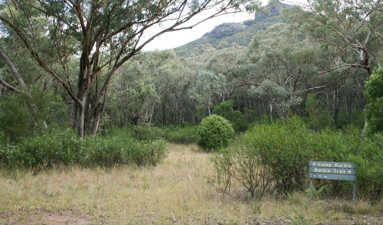
Burbie Camp
The coordinates that you can use in navigation applications to get to find Burbie Camp quickly are -31.2993314 ,148.9602601
Contact and Address
| Address: | Burbie Trail, Tonderburine NSW 2828, Australia |
|---|---|
| Postal code: | 2828 |
| Phone: | (02) 6825 4364 |
| Website: | http://www.nationalparks.nsw.gov.au/camping-and-accommodation/campgrounds/burbie-camp |
Opening Hours:
| Monday: | Open 24 hours |
|---|---|
| Tuesday: | Open 24 hours |
| Wednesday: | Open 24 hours |
| Thursday: | Open 24 hours |
| Friday: | Open 24 hours |
| Saturday: | Open 24 hours |
| Sunday: | Open 24 hours |
Location & routing
Reviews
There are no reviews yet!
You can review this Business and help others by leaving a comment. If you want to share your thoughts about Burbie Camp, use the form below and your opinion, advice or comment will appear in this space.
Photos of Burbie Camp

Burbie Camp On the Web
Burbie Camp | NSW National Parks
Burbie Camp. Warrumbungle National Park. Walk-in Burbie Camp, in Warrumbungle National Park, offers remote bush camping near a natural spring with wildlife, birdwatching, scenic views, and stargazing. Please contact the Warrumbungle National Park office on (02) 6825 4364.
Burbie Camp | Visitor info | NSW National Parks
Walk-in Burbie Camp, in Warrumbungle National Park, offers remote bush camping near a natural spring with wildlife, birdwatching, scenic views, and stargazing. Burbie Camp is in the Burbie precinct of Warrumbungle National Park. The campground is only accessible by foot.
Burbie Camp | What's nearby | NSW National Parks
Walk-in Burbie Camp, in Warrumbungle National Park, offers remote bush camping near a natural spring with wildlife, birdwatching, scenic views, and stargazing. Warrumbungle NP Visitor Information Centre 02 6825 4364 Contact hours: 9am to 4pm daily.
Burbie Camp Map - Warrumbungle National Park, New... - Mapcarta
Burbie Camp with an interactive map and directions. Burbie Camp from Mapcarta, the free map. Burbie Trail, Tonderburine ☎ +61 2 6825 4364. nationalparks.nsw.gov.au. Map.
Burbie Camp map, New South Wales
Google satellite map of Burbie Camp. Burbie Camp, Gilgandra Shire Council, New South Wales, Australia. Coordinates for GPS. latitude -31.299395 longitude 148.9601478.
Warrumbungle National Park _ Star Gazing | Rain | Camping
P Parking Burbie Camp Camp Pincham Camp Walaay. Road quality Unsealed roads. Warrumbungle NP Visitor Information Centre. 02 6825 4364 Contact hours: 9am to 4pm daily. Closed Christmas Day. Off John Renshaw Parkway, Warrumbungle National Park.
Pārējo apmešanās vietu darbība Pasta Indekss 2828 Gular...
Balor Hut Campground, Danu Campground, Gunneemooroo Campground, Camp Walaay - Warrumbungle Environmental Education Centre. Burbie Camp. +61 2 6825 4364+61 2 6825 4364. · www.nationalparks.nsw.gov.au.
Burbie Camp camping area (walk-in camping), Warrumbungle...
This walk-in only camping area has very basic facilities - pit toilets and wood BBQs - accessible along the fire trail to Mt Exmouth from Burbie Who to contact: Warrumbungle National Park Visitor Centre (02) 6825 4364 How to book: Warrumbungle National Park Visitor Centre (02) 6825 4364 for Balor...
Burbie camp nsw - English to Russian Translation
Translate Burbie camp nsw to English online and download now our free translation software to use at any time. Online Translation > English Translation > Translate Burbie camp nsw To Russian.
PDF Warrumb National Park Square Top Mountain Coonam
Locality Map. Burbie Camp. Exmouth. Horizon. Hurley's Camp Mountain. Breadknife. Belougery. Tonduron. Needle Mtn Gunneemooroo Camp. Road (unsealed) Fire trail (walkers only) Walking track Creek.